What 02CloudNative does
One study through the cloud-native geodata chain inside QGIS: find imagery in STAC catalogues, inspect and stream or clip Cloud Optimized GeoTIFFs, extract Overture Maps features, store them as GeoParquet, query them with spatial SQL and publish them as vector PMTiles. Every output records its source URLs, release, licence and retrieval time. The core runs on GDAL alone; DuckDB is an optional engine. No API keys and no accounts.
STAC and COG
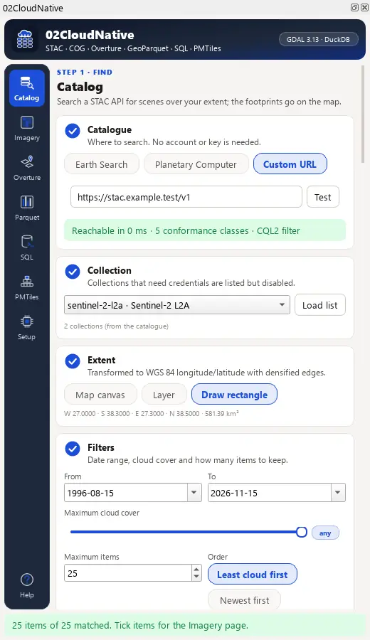
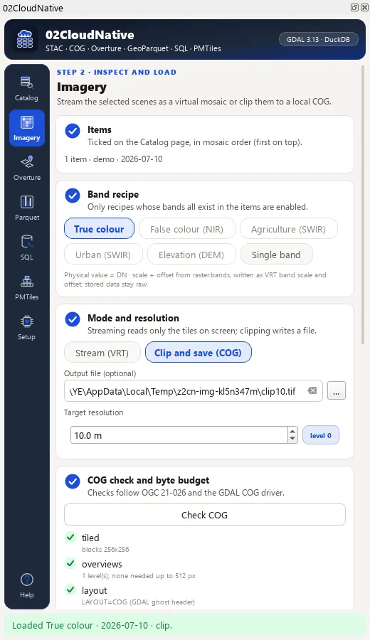
Earth Search, Microsoft Planetary Computer (anonymous SAS signing) or any unauthenticated STAC API; band recipes as a VRT mosaic streamed through /vsicurl/ with raster:bands scale and offset, or clipped to a local COG at an overview level; a COG check (OGC 21-026) and a byte budget before any download.
Overture and GeoParquet
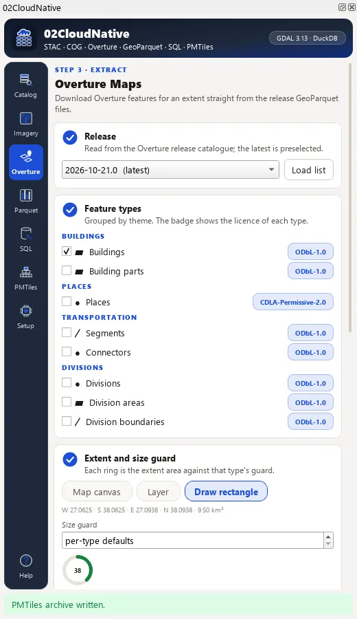
Buildings, places, transportation and divisions from the latest Overture release through GDAL's Parquet driver or DuckDB, with an area guard computed as ; GeoParquet 1.1 with a bbox covering and a spatial sort.
Spatial SQL and PMTiles
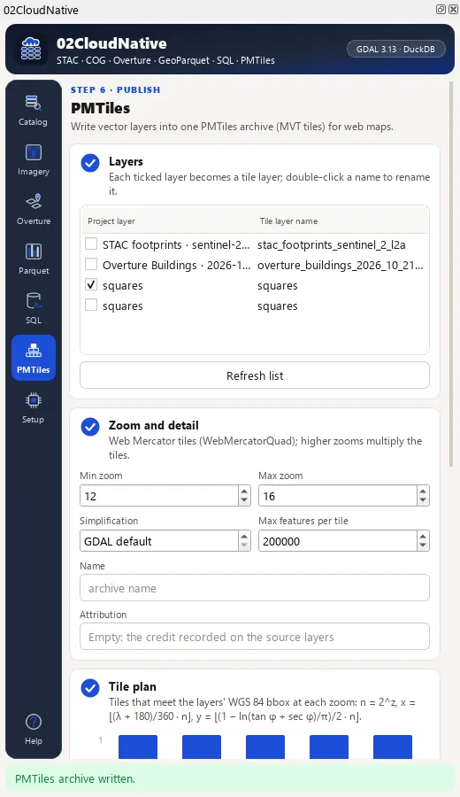
Spatial SQL over project layers, files and remote Overture views with DuckDB, or OGR's SQLite dialect without it; PMTiles v3 vector archives with a per-zoom tile plan and a header check of the written file.
Install, then run the demo
In QGIS, open Plugins › Manage and Install Plugins, search for 02CloudNative and install it, or install a release zip with Install from ZIP.
QGIS 3.28 or later (QGIS 4 included). GeoParquet needs GDAL's Parquet driver (GDAL 3.5+), the bbox covering GDAL 3.9+ and PMTiles export GDAL 3.8+; the Environment page shows what your install offers. DuckDB is optional (the duckdb Python package). Overture extraction works without it: 9 092 buildings for a 3.9 km² box in İzmir in 12.6 s through GDAL (14 Nov 2026).
Open the studio
Click the 02CloudNative studio toolbar button; the studio opens as a dock on the right.
Search a catalogue
On Catalog, keep Earth Search, choose sentinel-2-c1-l2a, zoom the map to a town, set a month and a 20 % cloud limit and press Search. The footprints appear on the map.
Stream a composite
On Imagery, tick the least cloudy item, choose True colour and Stream (VRT), press Load. The composite streams from the cloud; nothing is downloaded in advance.
Extract and publish
On Overture, tick Buildings and press Download (the area must be below the 25 km² guard). On PMTiles, tick the buildings layer, set zoom 12 to 15 and press Export.
The studio dock, page by page
The studio is a dock on the right of the QGIS window with an icon rail of seven pages and Help. Long steps run as QGIS background tasks with a progress bar and a Cancel button.
| Page | What it holds |
|---|---|
| 1. Catalog | Earth Search, Planetary Computer or a custom STAC URL with a Test button; collections (blocked ones disabled with the reason), extent from the canvas, a layer or a drawn rectangle, date range, cloud limit and item count; KPI cards, item cards with thumbnails and a footprints layer. |
| 2. Imagery | Band recipes (true colour, false colour NIR, agriculture, urban, DEM with hillshade, single band), Stream (VRT) or Clip and save (COG) at a target resolution, the COG check card and the byte-budget gauge. |
| 3. Overture | Release combo with the latest preselected, feature types with their licence badges, an area gauge against each type's size guard, engine (Auto, GDAL, DuckDB), intersects or centroid rule; output to layers, GeoPackage or GeoParquet. |
| 4. GeoParquet | Inspect the geo metadata of a file or URL, open it with a bbox filter, or write any layer as GeoParquet 1.1 with a bbox covering, compression and row-group size. |
| 5. SQL | Tables from project layers, files and Overture views; DuckDB or OGR SQLite; safe mode, templates, history, cancel, a result grid and result layers. |
| 6. PMTiles | Layers as tile layers, zoom range, simplification and feature limit per tile; a tile plan chart per zoom and a header check of the archive. |
| 7. Environment | The capability matrix of this QGIS (GDAL version, Parquet read and write, covering, PMTiles writer, DuckDB), a network check per catalogue, GDAL cache and timeout settings. |
Processing provider
The plugin registers a 02CloudNative provider with 13 algorithms in the Processing Toolbox, usable in models, batch mode and scripts.
| Group | Algorithm |
|---|---|
| Full chain | Cloud-native study (search, composite, Overture, GeoParquet, SQL, PMTiles, HTML report) |
| Catalog | STAC search |
| Imagery | STAC composite (stream or clip) |
| Imagery | Inspect a Cloud Optimized GeoTIFF |
| Imagery | Clip to a Cloud Optimized GeoTIFF |
| Overture | Overture Maps extract |
| GeoParquet | Inspect GeoParquet |
| GeoParquet | Read GeoParquet |
| GeoParquet | Write GeoParquet |
| SQL | Spatial SQL |
| PMTiles | Web Mercator tile plan |
| PMTiles | Export vector PMTiles |
| Environment | Capabilities of this QGIS |
Full manual
02CloudNative manual
Every page and parameter, methods and formulas, output fields, the worked demo example, limitations and references.
Citation and licence
| Name | 02CloudNative - Cloud-Native Data Studio |
| Package | zero2cloudnative |
| Version | 0.1.0 |
| QGIS | 3.28 or newer; QGIS 4 supported |
| Licence | GPL-2.0-or-later (LICENSE) |
| Developer | Geophilo · Yusuf Eminoğlu (ORCID 0009-0005-6000-2934) |
| Source | gitlab.com/geophilo1/zero2cloudnative |
| Issues | gitlab.com/geophilo1/zero2cloudnative/-/work_items |
| Hub | plugins.qgis.org search: zero2cloudnative (listing pending) |
| Revision | November 2026 |
Eminoğlu, Y. (2026). 02CloudNative - Cloud-Native Data Studio (version 0.1.0) [QGIS plugin]. https://gitlab.com/geophilo1/zero2cloudnative