What 02EarthEmbeddings does
Mapping with the Google AlphaEarth Foundations Satellite Embedding dataset (annual 2017 to 2025, 10 m, 64 channels, CC BY 4.0) in QGIS. The plugin reads the public Cloud-Optimised GeoTIFFs without an Earth Engine account, turns the bottom-up, quantised tiles into a north-up cube of unit vectors across UTM zones, and carries a study to similarity search, label-free clustering, few-label classification, design-based accuracy and area estimates, multi-year change, polygon embeddings and an HTML report.
Correct cube from public tiles
Tiles are flipped north-up, de-quantised as with as nodata, normalised to unit length and mosaicked across UTM zones; an estimate of pixels, download size and tiles comes before any fetch.
Similarity, clusters, classes
Mean prototype, nearest example or contrast search with Otsu, top-percent or fixed thresholds; spherical -means with model-selection curves; -NN, nearest prototype and logistic regression in NumPy with spatial block and random cross-validation side by side.
Estimates you can report
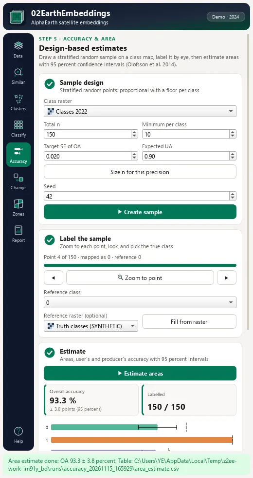
Stratified random samples and Olofsson et al. (2014) area estimates with 95 % confidence intervals for area, OA, UA and PA; change distance with Otsu, MAD or stable-reference thresholds; polygon embeddings with coherence .
Install, then run the demo
In QGIS, open Plugins › Manage and Install Plugins, search for 02EarthEmbeddings and install it, or install a release zip with Install from ZIP.
QGIS 3.28 or later (QGIS 4 included). GDAL and NumPy ship with QGIS. Optional: scikit-learn (random forest) and pyarrow (a second reader for the Parquet tile index). One area of interest holds at most 25 million pixels per year at the chosen pixel size (about at 10 m). Annual embeddings show that change happened, not when within the year.
Open the lab
Click the 02EarthEmbeddings toolbar button; the lab opens as a dock on the right.
Load the demo cube
On Data, press Load demo cube (synthetic): a pixel cube at 10 m in EPSG:32635 for 2022 to 2024 with five planted classes, one novel class and a 24 ha block that changes class in 2024. Every layer is marked SYNTHETIC - not AlphaEarth data.
Cluster and classify
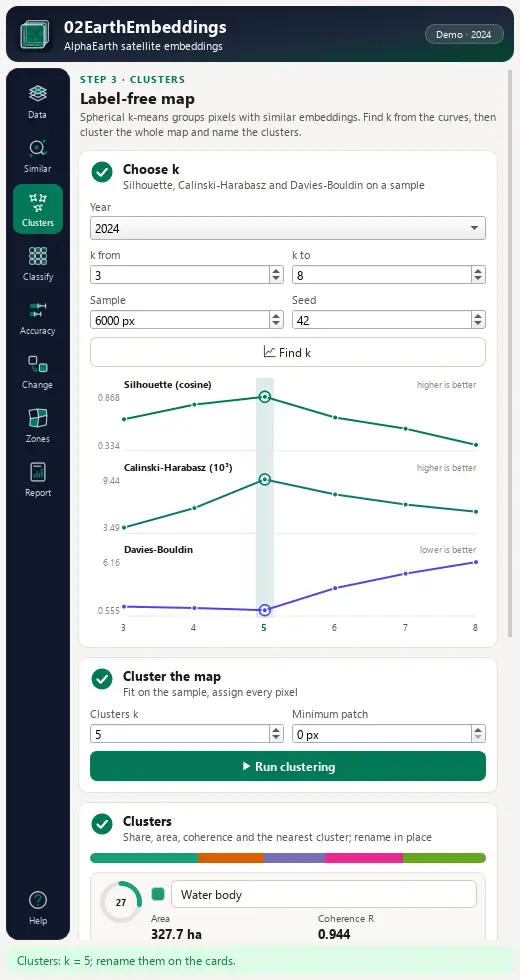
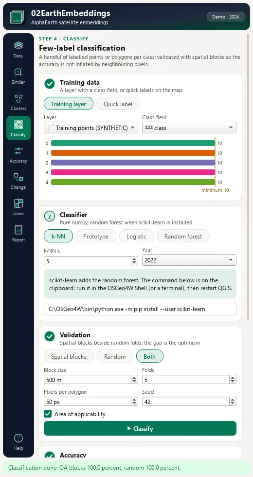
On Clusters, Find k (the silhouette peaks at ), then Run clustering. On Classify, use the demo training points (field class) with 500 m blocks and compare OA (blocks) with OA (random); the AOA layer flags the novel class.
Change and report
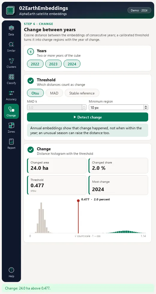
On Change, years 2022 to 2024 with Otsu: the changed area is 24 ha and the change year 2024. On Report, write the HTML report.
The lab dock, page by page
The lab is a dock on the right of the QGIS window with an icon rail of eight pages and Help. Long steps run as QGIS background tasks with a progress bar and a Cancel button.
| Page | What it holds |
|---|---|
| 1. Data | Area of interest, year chips 2017 to 2025, pixel size 10 to 80 m, source (Google Cloud, Source Cooperative mirror, a local folder or raster layers), Check connection, an estimate card, Fetch cube and Load demo cube (synthetic); a PCA colour composite is added. |
| 2. Similar | Positive and negative examples from map clicks or layers, scoring rule, threshold on a live histogram, minimum mapping unit and a ranked region list. |
| 3. Clusters | Find k draws the silhouette, Calinski-Harabasz and Davies-Bouldin curves; spherical -means; renamable cluster cards with share, area and coherence. |
| 4. Classify | Training layer or quick labels; OA from spatial blocks and from random folds, macro-F1, quantity and allocation disagreement, a confusion matrix, probability, margin, dissimilarity-index and area-of-applicability layers. |
| 5. Accuracy | Stratified random sample design sized for a target standard error, a labelling helper that writes ref_class, and Olofsson area estimates with confidence intervals, also as CSV. |
| 6. Change | Distance between years, thresholds, change year, change regions and a before/after PCA pair. |
| 7. Zones | Polygon embeddings (e00 to e63), coherence, similarity to a reference zone and a CSV similarity matrix. |
| 8. Report | One self-contained HTML file with provenance, attribution, formulas, KPIs, tables and references; an export of all rasters and a GeoPackage of the vectors. |
Processing provider
The plugin registers a 02EarthEmbeddings provider with 13 algorithms in the Processing Toolbox, usable in models, batch mode and scripts.
| Group | Algorithm |
|---|---|
| Data | Synthetic demo cube |
| Data | Estimate download (AlphaEarth tiles) |
| Data | Fetch AlphaEarth embeddings |
| Data | PCA colour composite |
| Similarity | Similarity search (from examples) |
| Clusters | Choose the number of clusters |
| Clusters | Label-free clusters (spherical k-means) |
| Classification | Few-label classification |
| Accuracy and area | Accuracy sample (stratified random) |
| Accuracy and area | Area estimate and accuracy (Olofsson) |
| Change | Change between years |
| Zones | Polygon embeddings (zones) |
| Workflow | Earth Embeddings Lab (full workflow and report) |
Full manual
02EarthEmbeddings manual
Every page and parameter, methods and formulas, output fields, the worked demo example, limitations and references.
Citation and licence
| Name | 02EarthEmbeddings - Earth Embeddings Lab |
| Package | zero2earthembeddings |
| Version | 0.1.0 |
| QGIS | 3.28 or newer; QGIS 4 supported |
| Licence | GPL-2.0-or-later (LICENSE) |
| Developer | Geophilo · Yusuf Eminoğlu (ORCID 0009-0005-6000-2934) |
| Source | gitlab.com/geophilo1/zero2earthembeddings |
| Issues | gitlab.com/geophilo1/zero2earthembeddings/-/work_items |
| Hub | plugins.qgis.org search: zero2earthembeddings (listing pending) |
| Revision | November 2026 |
Eminoğlu, Y. (2026). 02EarthEmbeddings - Earth Embeddings Lab (version 0.1.0) [QGIS plugin]. https://gitlab.com/geophilo1/zero2earthembeddings