An Environmental Noise Directive (2002/49/EC) road-noise study in QGIS, from a road layer to exposure tables and health outcomes: CNOSSOS-EU octave-band emission, propagation over buildings and barriers with ground effect and favourable conditions, Lden and Lnight grids, facade receivers, END exposure tables, Directive (EU) 2020/367 health outcomes and mitigation scenarios.
Version: 0.1.1QGIS: 3.28+ / 4.xLicence: GPL-2.0-or-laterDeveloper: GeophiloLanguage: English
01 · Overview
What 02NoiseLab does
An Environmental Noise Directive (2002/49/EC) road-noise study in QGIS, from a road layer to exposure tables and health outcomes: CNOSSOS-EU octave-band emission, propagation over buildings and barriers with ground effect and favourable conditions, Lden and Lnight grids, facade receivers, END exposure tables, Directive (EU) 2020/367 health outcomes and mitigation scenarios.
Emission
CNOSSOS-EU road sources
Rolling and propulsion noise per octave band for categories 1, 2, 3, 4a and 4b, with speed, temperature, gradient, junction acceleration, studded tyres and road surface corrections.
Propagation
Buildings, barriers, ground
Geometric divergence, ISO 9613-1 absorption, ground effect with the G factor, diffraction over buildings and barriers, homogeneous and favourable conditions per period.
Exposure and health
END and WHO tables
Facade receivers with most-exposed and quiet-facade flags, END Annex VI tables, WHO 2018 exceedance, high annoyance, high sleep disturbance and ischaemic heart disease.
02 · Install and quick start
Install, then run the demo
In QGIS, open Plugins › Manage and Install Plugins, search for 02NoiseLab and install it, or install a release zip with Install from ZIP.
QGIS 3.28 or later (QGIS 4 included). NumPy and GDAL ship with QGIS; SciPy is used for a faster neighbour search when present, with identical results without it. The plugin makes no network calls. Reflections and lateral diffraction are not modelled in this version, and the model does not claim certification against ISO/TR 17534-4.
Click the 02NoiseLab toolbar button; the lab opens as a dock on the right.
Load the demo district
On Data, press Load demo district: a 1×1km district in EPSG:32635 with an arterial (AADT 30000, 8% heavy, 70km/h), a collector and a local street, 160 buildings with 5 844 residents, a 4 m barrier and a park with G=1.
Run all steps
Press Run all steps: 8 384 grid and 3 520 facade receivers at the 10 m default cell, about half a minute on a desktop machine.
Read and compare
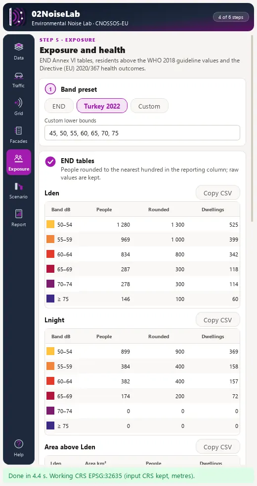
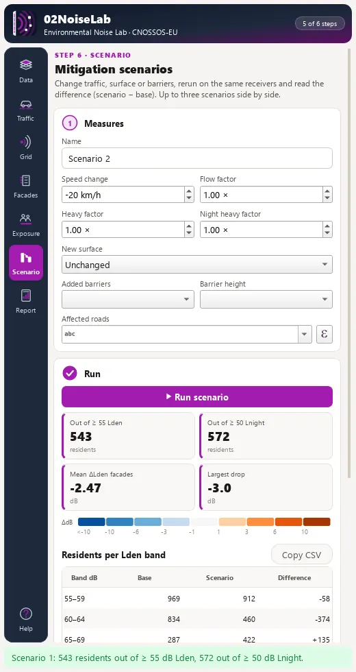
Exposure & health reports 2 505 residents at Lden≥55dB and 1 872 at Lnight≥50dB. On Scenarios, a speed reduction Δv=−20km/h on the arterial moves about 330 residents out of Lden≥55dB.
03 · The dock
The lab dock, page by page
The lab is a dock on the right of the QGIS window with an icon rail of 7 pages and Help. Long steps run as QGIS background tasks with a progress bar and a Cancel button.
Page
What it holds
1. Data
Roads, buildings, optional population polygons, barriers, ground-factor polygons and DEM; a working CRS badge and Load demo district.
2. Traffic
AADT and heavy-vehicle share, period flow fields or road-class defaults; period shares and scheme; Compute emission fills a table of LW′ per road and period with an octave spectrum.
3. Propagation
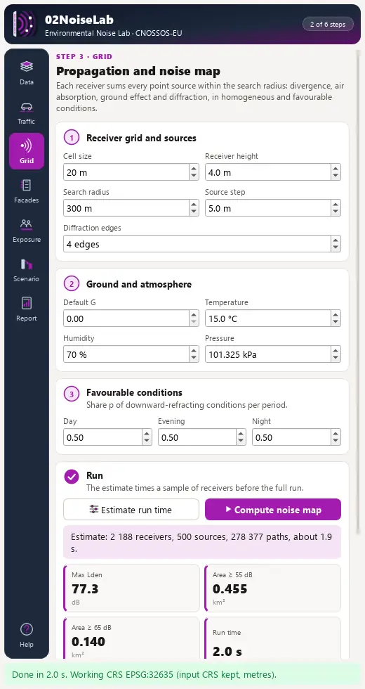
Grid cell, receiver height, search radius, ground and atmosphere, favourable occurrence; Estimate run time before Compute noise map writes Lden, Lnight, Ld and Le GeoTIFFs and isophones.
4. Facades
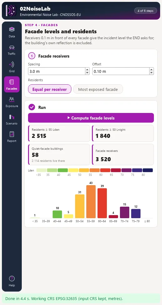
Receiver spacing and offset, allocation of residents, most-exposed Lden and Lnight per building and the quiet-facade flag.
5. Exposure & health
Band preset (END, Turkey 2022, custom), END tables with copy-as-CSV, WHO 2018 guideline gauges and health cards.
6. Scenarios
Speed, flow and heavy-vehicle changes, surface, added barriers and a road filter; a ΔLden raster, the exposure change table and up to three named scenarios side by side.
7. Report
HTML report, END tables as CSV, GeoTIFF grids and a GeoPackage with every vector layer.
Propagation page of the 02NoiseLab dock with grid, ground and atmosphere settings and the run estimate.Facades page of the 02NoiseLab dock with facade receivers and quiet-facade buildings.Exposure and health page with END tables for Lden and Lnight.Scenarios page with a speed reduction on the arterial and the exposure change.
04 · Processing
Processing provider
The plugin registers a 02NoiseLab provider with 15 algorithms in the Processing Toolbox, usable in models, batch mode and scripts.
Group
Algorithm
Traffic and emission
Traffic flows per vehicle category
Traffic and emission
Road emission LW′ (CNOSSOS-EU)
Traffic and emission
Point sources along roads
Receivers and obstacles
Grid receivers
Receivers and obstacles
Facade receivers
Receivers and obstacles
Obstacle heights
Propagation and indicators
Noise levels at receiver points
Propagation and indicators
Lden and Lnight from period levels
Propagation and indicators
Isophone polygons
Exposure and health
Assign residents to facade receivers
Exposure and health
END exposure table
Exposure and health
Area above Lden thresholds
Exposure and health
Health outcomes (Directive 2020/367)
Lab
Environmental noise lab (whole chain)
Lab
Mitigation scenario (delta maps)
05 · Companion Python SDKs (pip install)
Headless PyPI Counterparts for 02NoiseLab
Every analytical engine in 02NoiseLab pairs with standalone, MIT-licensed pure-Python packages in the 80-SDK Geophilo ecosystem (Environmental Acoustics, Turkish Noise Law & Street LOS) for reproducible notebooks, batch pipelines and automated testing.