What 02SentinelChange does
A Sentinel-1 or Sentinel-2 change study from an area of interest to a reported map, without an account and with nothing to install. The plugin searches Element 84 Earth Search and the Microsoft Planetary Computer through STAC, reads only the area of interest from the cloud-optimised GeoTIFFs, masks clouds with the Scene Classification, builds clear before and after composites on one UTM grid and computes spectral indices, burn severity, radar flood extent, index change and per-pixel break dates.
Clear pixels on one grid
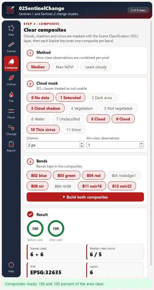
STAC search with a timeline and Before/After baskets; SCL classes masked and dilated by 2 pixels; per-pixel median, maximum-NDVI or least-cloudy composites; 14 indices with keys after Awesome Spectral Indices.
Burn severity
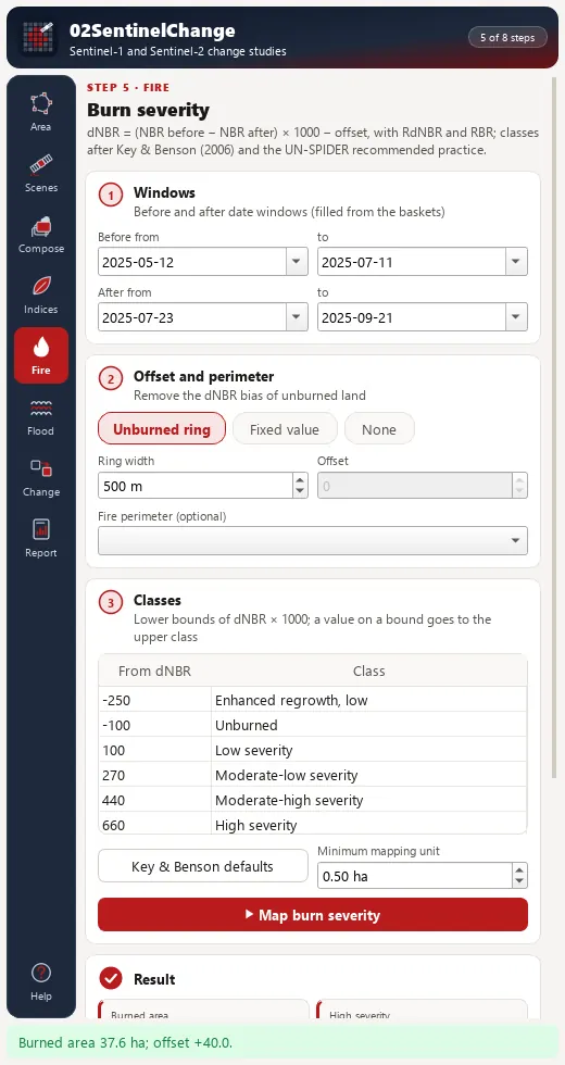
with an unburned-ring offset, and ; classes after Key & Benson (2006) and UN-SPIDER.
Radar and time series
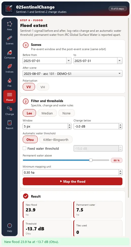
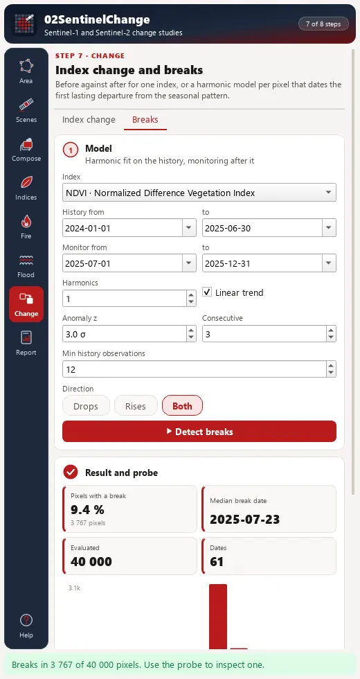
Sentinel-1 GRD calibrated to , Lee filter, log-ratio change with Otsu or Kittler-Illingworth thresholds on split-based tiles and a JRC permanent-water mask; harmonic regression on a history window with breaks flagged by consecutive anomalies beyond .
Install, then run the demo
In QGIS, open Plugins › Manage and Install Plugins, search for 02SentinelChange and install it, or install a release zip with Install from ZIP.
QGIS 3.28 or later (QGIS 4 included). Only qgis.core, GDAL and NumPy are required; SciPy is used for speed when present. Sentinel-1 GRD is warped with its GCPs; thermal-noise removal and terrain correction are not in this version. Every output carries "Contains modified Copernicus Sentinel data [year]".
Open the lab
Click the 02SentinelChange toolbar button or Plugins › 02SentinelChange; the lab opens as a dock on the right.
Load the demo
On Area, press Load demo: 61 synthetic Sentinel-2 dates and four Sentinel-1 dates ( pixels at 10 m, EPSG:32635) with a planted burn scar (15 Jul 2025), a lake and a flood on the last radar date.
Composite and map
Composite › Build both composites; Indices › preset Fire › Compute indices; Fire › Map burn severity: the ring offset recovers the planted bias of about 40 dNBR units and the burned area is about 37.6 ha. Flood › Map the flood: about 23.9 ha of new flood, with the lake reported as permanent water.
Breaks and report
Change › Detect breaks with history 2024-01-01 to 2025-06-30 and monitoring 2025-07-01 to 2025-12-31, then Probe a pixel inside the scar. Report › Write the report.
The lab dock, page by page
The lab is a dock on the right of the QGIS window with an icon rail of eight pages and Help.
| Page | What it holds |
|---|---|
| 1. Area | Area of interest from a polygon layer, the canvas or a drawn rectangle; resolution chips (10, 20, 30, 60 m), a working CRS badge, a pixel-budget gauge, cache and output folders, source status chips and Load demo. |
| 2. Scenes | Sentinel-2 L2A or Sentinel-1 GRD, date range, cloud and area cover limits, source; a timeline strip and a scene table with Before and After baskets. |
| 3. Composite | Median, maximum-NDVI or least-cloudy; SCL classes to mask, dilation and bands; both composites with true-colour and SWIR false-colour renderers. |
| 4. Indices | A searchable checklist of the 14 indices with formula, bands and reference; presets Vegetation, Water, Built-up, Fire. |
| 5. Fire | Pre and post windows, offset mode, ring width, optional perimeter, editable class thresholds and minimum mapping unit; KPI cards and a severity bar chart. |
| 6. Flood | Reference window, flood scene, polarisation, speckle filter, log-ratio threshold, automatic threshold method, permanent-water limit; a backscatter histogram with the threshold line. |
| 7. Change | Index change (difference or relative) and break detection with history and monitoring windows, harmonics, and consecutive anomalies; a break-date map and a pixel probe. |
| 8. Report | The HTML report, a GeoPackage of burned and flood polygons and a folder of Cloud Optimized GeoTIFFs. |
Processing provider
The plugin registers a 02SentinelChange provider with 10 algorithms in the Processing Toolbox, usable in models, batch mode and scripts.
| Group | Algorithm |
|---|---|
| Scenes | Search Sentinel scenes |
| Scenes | Scene from local files |
| Scenes | Demo data (synthetic scenes) |
| Composites and indices | Before and after composites |
| Composites and indices | Spectral indices |
| Fire | Burn severity (dNBR, RdNBR, RBR) |
| Flood | Flood extent (Sentinel-1) |
| Change | Index change |
| Change | Break detection (index time series) |
| Study and report | Change study (full pipeline and report) |
Full manual
02SentinelChange manual
Every page and parameter, methods and formulas, output fields, the worked demo example, limitations and references.
Citation and licence
| Name | 02SentinelChange - Sentinel Change Lab |
| Package | zero2sentinelchange |
| Version | 0.1.0 |
| QGIS | 3.28 or newer; QGIS 4 supported |
| Licence | GPL-2.0-or-later (LICENSE) |
| Developer | Geophilo · Yusuf Eminoğlu (ORCID 0009-0005-6000-2934) |
| Source | gitlab.com/geophilo1/zero2sentinelchange |
| Issues | gitlab.com/geophilo1/zero2sentinelchange/-/work_items |
| Hub | plugins.qgis.org search: zero2sentinelchange (listing pending) |
| Revision | November 2026 |
Eminoğlu, Y. (2026). 02SentinelChange - Sentinel Change Lab (version 0.1.0) [QGIS plugin]. https://gitlab.com/geophilo1/zero2sentinelchange